My hike up Mt. Amuyao was completely impulsive. I was planning to stay in Bontoc for an indefinite period of time, but after five nights, the homestay I was staying at was reserved for several nights prior to my stay there. I had to leave. A series of encounters led me to Barlig and climbed Mt. Amuyao.
About Mt. Amuyao
Standing at 2702 masl, Mt. Amuyao was formerly known as the highest mountain in Mountain Province and the 10th highest mountain in the Philippines. Today however, as higher mountains were discovered, it was pushed down on the list. The current known mountain to be the highest in Mountain Province is Mt. Kalawitan in Sabangan, Mountain Province.
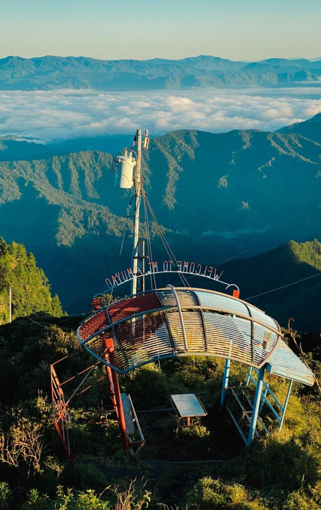
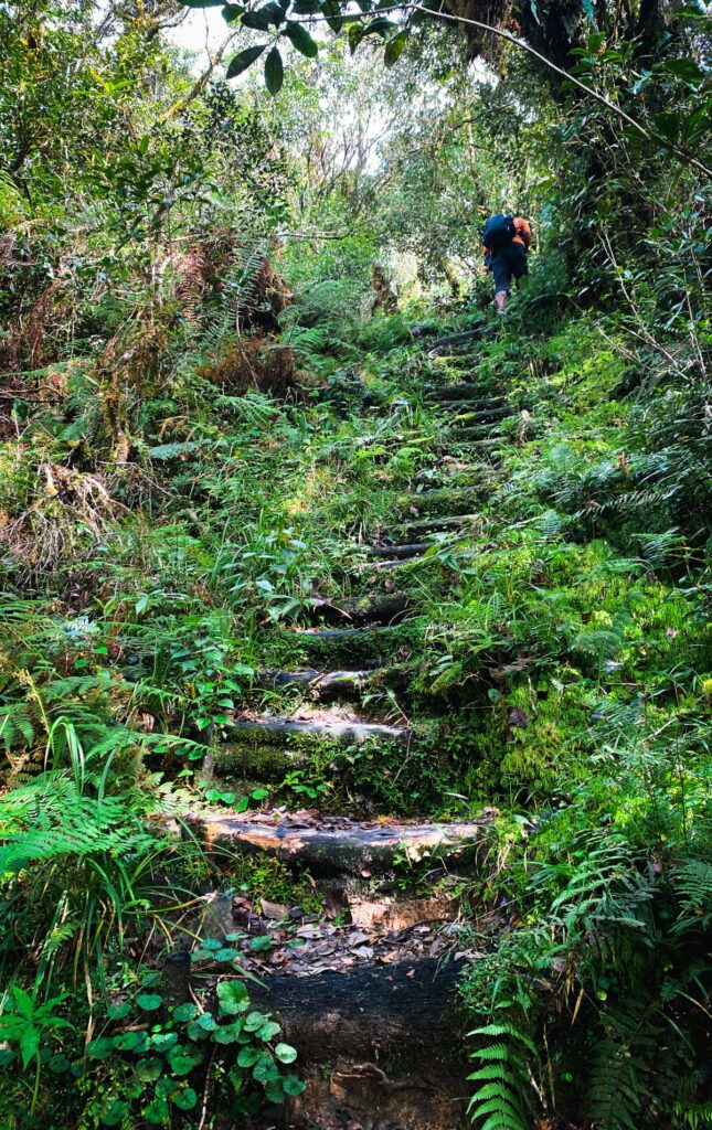
The distance from the jump-off point to the summit is around 6 km and the hike up takes 3 to 8 hours. Because of its prime location, PT&T, ABS CBN, and GMA built transmission towers and bunkers atop Mt Amuyao. Because of this, the trail is also well-established, with stairs leading up to the summit.
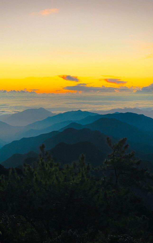
The summit provides a 360-degree view of the Cordillera mountain ranges and if you’re lucky, a clear sight of the most prominent mountains in Luzon, Mt. Pulag and Mt. Napulauan in Benguet.

There are two known trails mountaineers choose to hike from; the Barlig Backtrail and the Batad-Mayoyao traverse. However the Barlig Tourism Office only allows the Barlig Backtrail route.
Pre-Hike
When I checked out from the homestay, I really didn’t know where to go. But I remembered the conversation I had with a teacher back at the homestay, who’s from Paracelis, Mountain Province. When I brought up how I expected it to be cold in Bontoc and found out that it’s actually hot, she mentioned that one of the colder towns in Mountain Province is Barlig. Whenever she’s traveling to Bontoc from Paracelis, she can tell they’re passing by Barlig when it feels cold.
I love to live somewhere cold and since the heat in Bontoc was unbearable when I was walking through the town at lunch, I went straight for the jeep headed to Barlig.
Barlig pretty much is a town where everyone knows each other. When I rode the jeep, the people were having a conversation and it already feels like they live in one community.
Nestled in the Cordillera mountains, Barlig is far from a tourist destination so only hikers go to Barlig to climb Mt. Amuyao. As a non-local planning to stay in Barlig for multiple days, the locals I met were always asking me if I’m going to hike the mountain. I would answer “‘di ko pa po sure” or “‘di ko po alam”. I’d get curious stares whenever I say I’m not sure whether I would climb the mountain because the locals are not used to travelers staying in Barlig.
After feeling the pressure of the locals always asking me when my climb would be, I finally inquired at the tourism office on my third day in Barlig. At that time, I planned my day very well. I will be working from the homestay continuously for hours after I inquire at the tourism office. But as the impulsive person that I am, when I left the tourism office, I already had a sleeping bag in hand that one of the staff offered me to borrow because I’ll be hiking in two hours.
I paid the 25 pesos registration fee at the municipal hall and went back to the homestay to check-out and prepare for the hike.
Hike Journal
Day 1
Barlig is full of stairs. If you walk around town, it would barely be a walk because the town is just full of stairs. Due to this everyday stair workout, the guides and locals of Barlig easily summit the mountain in 3 hours. But it takes longer if they’re carrying an overnight pack. Meanwhile they said it takes most hikers 5 to 8 hours to reach the summit, with an overnight pack.
Our hike started at 13:00 and I just cannot stress enough how many stairs there are in Barlig. You can literally call the hike the “stairway to heaven”, especially if you arrive at the summit with a sea of clouds all around it.
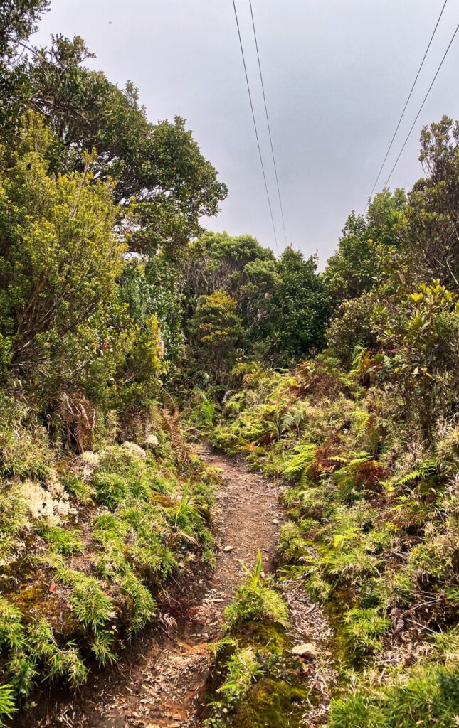
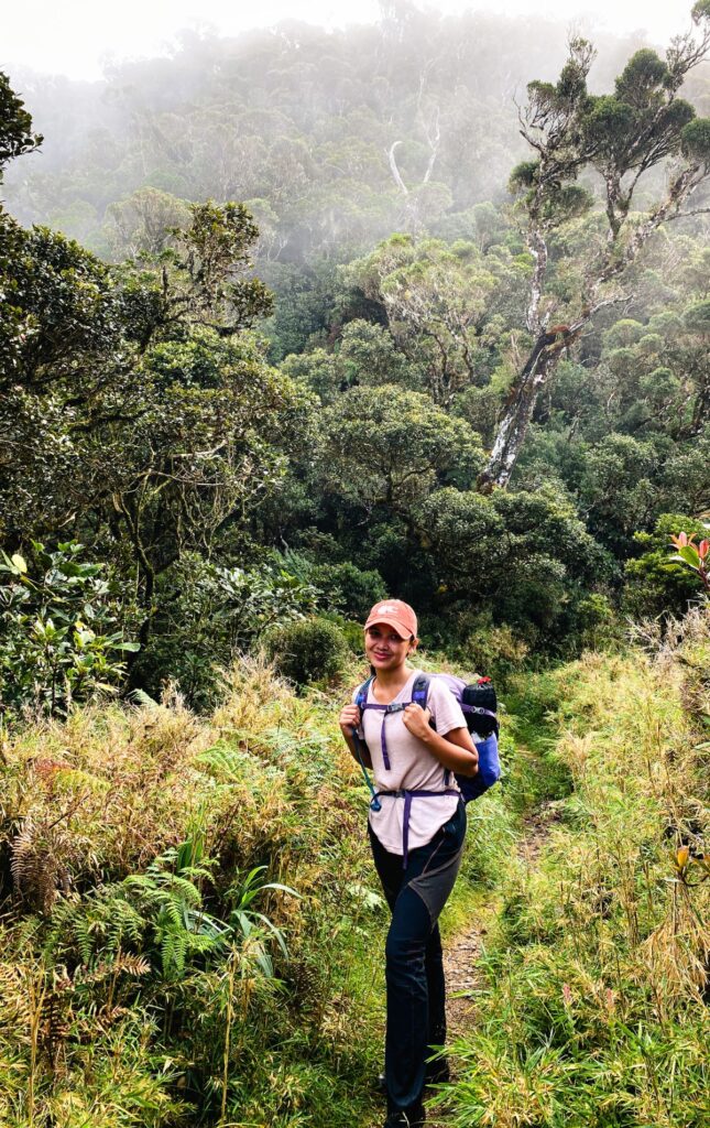
We dropped by Macalana BLGU to register and pay the environmental fee, then left at 13:20. The trail is well-established and the hike up is relatively short with only 5 to 6 km to cover. From the town, you will pass above rice fields, through a pine tree forest, a mossy forest, a bonsai forest, then there goes the summit.
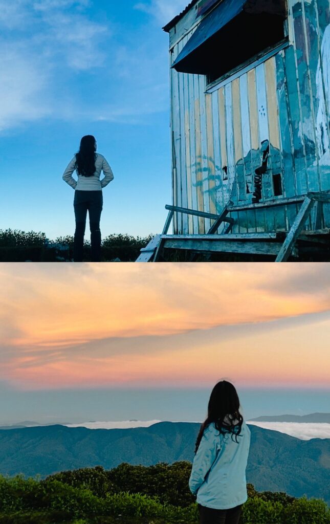
We arrived at the summit at 16:40.
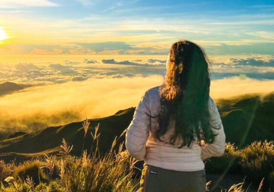
The sunset was magical.
Day 2
I woke up to an alarm at 5:00. With my borrowed sleeping bag on my shoulders, I went outside to watch the sunrise. When I opened the door from the bunk house, there was already a yellow orange line that showed the sun rising. It was really beautiful. I watched the sunrise by myself at the summit and I couldn’t fix looking at one view for a long time. The landscape all around the summit was amazing, from north south east to west. You can even see Luzon’s highest mountain, Mt. Pulag, and the trail that leads up to the summit. But the most beautiful view was in the east where the sun was rising.
After an hour, my guide checked up on me at the summit, but came down after a few minutes. When the sky came back to its natural colors, that’s when I also went back to the bunk house. We had breakfast by 7:00 and I decided to hike down at 8:30 so it’s not too hot during the hike down.
Since the guide decided to let me go first on the trail, I had many chances to ask him to take photos of me on the trail.
After 3 hours of hiking down the stairs, we managed to reach the village back at 10:30.
All you need to know
Water Source
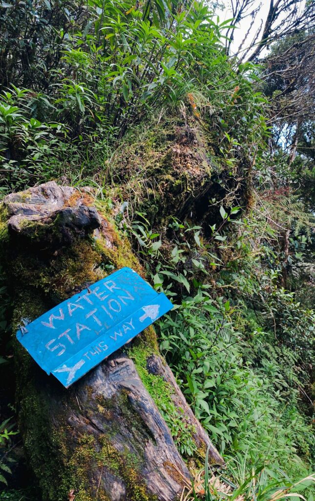
There is a water source 15 to 30 minutes before reaching the summit.
Requirements
No requirements needed.
Transportation
From Bontoc, take the jeep to Barlig in front of Cathedral of All Saints church. The jeep ride takes 1 to 2 hours and costs Php 130.00.
The jeep ride back to Bontoc passes by Barlig every 6 am and 2 pm, and also costs Php 130.00.
Hiking Fees
Barlig Municipal Hall
Registration Fee: 25
Optional Certificate: 70
Macalana Barangay Hall
Environmental Fee: 50
Guide Fee
Day Hike (Strictly from 5 am to 5 pm only): 2,000
Overnight: 2,500
Lodge
Halfway Inn & Restaurant: 450/night
Sample Expenses for an Overnight Solo Hike
| Mt. Amuyao (Barlig Backtrail) | 3,585.00 |
| Hiking Fees | 75.00 |
| Municipal Hall | 25.00 |
| Barangay Hall | 50.00 |
| Optional Certificate at Php 70 | 0.00 |
| Guide Fees | 2500.00 |
| Day Hike at Php 2,000 (5 am to 5 pm) | 0.00 |
| Overnight Hike at Php 2,500 | 2,500.00 |
| Transportation | 260.00 |
| JEEP Bontoc to Barlig (1 pm) | 130.00 |
| JEEP Barlig to Bontoc (6 am and 2 pm) | 130.00 |
| Food & Lodge | 750.00 |
| Halfway Inn & Restaurant (rate per night) | 450.00 |
| 3 Meals | 300.00 |
Sample Itinerary
Day 0
13:00 Bontoc Departure
15:00 Barlig Arrival
15:30 Homestay Check-In
Day 1
10:00 Homestay Check-Out
11:00 Lunch
12:00 Start Hike
16:00 Reach Summit
Day 2
08:30 Start Hike
12:00 Reach Town
14:00 Barlig Departure
You may contact one of the staff of Barlig Tourism Office at 09066148093 for inquiries.
Tips
- Spend an overnight at the summit to experience both sunset and sunrise.
- There is a bunk house at the summit for public use but I wouldn’t recommend taking shelter inside without bringing a tent. There are rats living in the bunk house and I can just imagine the worst– waking up to rats taking advantage of your body heat.